
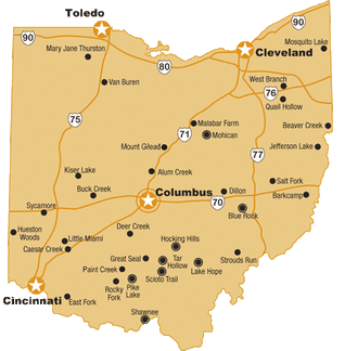
WEATHER


Lorain County OHC Day Rides & Campouts Locations
*** Disclaimer - these maps and descriptions have been gathered by members and to the best of our knowledge are accurate but are not necessarily the official map for the location. Descriptions are subjective and conditions can change at any time so please ride with care. Many Parks close trails during wet weather so it is best to check before you head out. Trail difficulty is rated on the scale of 1 to 4 with 1 being easy and 4 being difficult/challenging. ***
!!! You will need Adobe Acrobat Reader to view some of these files.
It can be downloaded at the Adobe website. !!!

AEP Conesville Horse Area (Fallon Park):
Conesville, OH. | Trail Difficulty: 2.5 | Trail Miles: 25 | High Lines | Campsites: Large open area, parking flexible | Non-Potable Water | Porta-Johns | AEP Permit Required | * Description 1 * Description 2 * Trail Map * Permit Link
* GPS: 40.186720, -81.840138
Alum Creek State Park:
Deleware, OH. | Trail Difficulty: 2.5 | Trail Miles: 43.0 | Campsites: 30 | High Lines | Potable Water| Port-a-Potty | Horse Wash Station | Horse Mount | No Electric | * Description 1 * Description 2 * Map * Map2 * Park Map * Camp Map * GPS: 40.289408, -82.962041
Barkcamp State Park:
Belmont, OH. | Trail Difficulty: 1.5 | Trail Miles: 30.0 | Campsites: 27 | High Lines | Non-Potable Water| Pit Toilets | Showers | Horse Wash Station | Horse Ramp | Electric | * Description 1 * Description 2 * Map * Map2 * Camp Map
* GPS: 40.041338, -81.023706
Beaver Creek State Park:
East Liverpool, OH. | Trail Difficulty: 3.0 | Trail Miles: 27.0 | Campsites: 99 | High Lines | Non-Potable Water | Pit Toilets | Horse Ramp | * Description 1 * Description 2 * Directions * Map1 * Map2 * Map3
* GPS: 40.715248, -80.588650
Bedford Reservation:
Bedford, OH. | Trail Difficulty: 2.5 | Trail Miles: 18.0 | * Description * Map * Map2
* GPS: Hemlock Creek: 41.375351, -81.575372
Blue Rock State Forest:
Blue Rock, OH. | Trail Difficulty: 1.5 | Trail Miles: 26 | * Description * Description 2 * Map * Map2 * Camp Map
* GPS: 39.820121, -81.856277
Brecksville Reservation:
Brecksville, OH. | Trail Difficulty: 2.5 | Trail Miles: 20 | * Description * Description 2 * Map * Map2 * Directions
* GPS: 41.315309, -81.622658
Carlisle Reservation:
LaGrange, OH. | Trail Difficulty: 1.0 | Trail Miles: 14 | Restrooms | Water | * Description * Map * Map2
* GPS: 41.295285, -82.152799
Charlemont Reservation:
Wellington, OH. | Trail Difficulty: 1.5 | Trail Miles: 6 | No restroom facility | No Water | * Description * Map
* GPS: 41.071272, -82.269341
Edison Woods Preserve:
Berlin Heights, OH. | Trail Difficulty: 1.0 | Trail Miles: 6 | Picnic Area. | Water For Horses | Pit Toilets | * Description * Map * Map2
* GPS Ceylon Rd. (SR 61): 41.340523, -82.493683
* GPS Smokey Rd.: 41.355006, -82.479067
* GPS Mason Rd.: 41.333503, -82.483180
Harrison State Forest:
Harrison, OH. | Trail Difficulty: 1.5 | Trail Miles: 25 | High Lines | Campsites: 27 | * Description * Map * Map2 * Map3
* GPS: 40.339431, -81.025966
Hinckley Reservation:
Hinckley, OH. | Trail Difficulty: 1.5 | Trail Miles: 10.0 | * Description * Map
* GPS 606 Lot: 41.222016, -81.730912
* GPS Ledge Lake Lot: 41.203623, -81.727285
* GPS: Worden's Ledges Lot: 41.202105, -81.717107
Hocking State Forest:
Rockbridge, OH. | Trail Difficulty: 3.5 | Trail Miles: 40.0 | Campsites: 23 | High Lines | Non-Potable Water| Pit Toilets | * Description * Map * Map2 * Map3
* GPS: Three Reasons Farm: 39.478030, -82.561609
* GPS: Stacked Stones Retreat: 39.460318, -82.616343
* GPS: Pine Creek Horseman's Camp: 39.441202, -82.589005
Kipton Reservation:
Oberlin, OH. | Trail Difficulty: 1.5 | Trail Miles: 4.0 | No Restroom Facilities. | No Water | * Description * Description 2 * Map
* GPS: 41.252277, -82.303292
Letha House Park:
Chatham, OH. | Trail Difficulty 1.0 | Trail Miles: 1.6 | Restrooms | No Water | * Description 1 * Description 2 * Map
* GPS: 41.115102, -82.057851
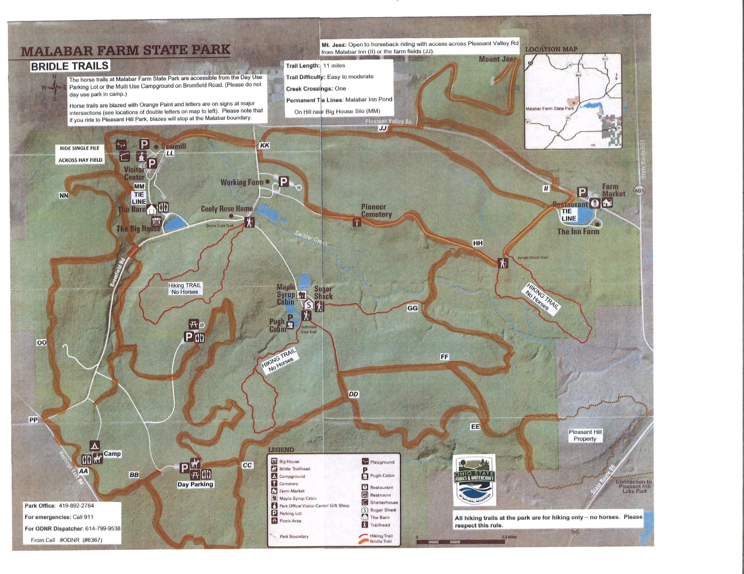
Malabar Farm:
Lucas, OH. | Trail Difficulty: 1.5 | Trail Miles: 11.0 | Campsites: 15 | High Lines | Non-Potable Water | Pit Toilets | * Description 1 * Description * Map
* GPS: Day Use Parking: 40.641956, -82.398695
* GPS: Camping: 40.643073, -82.401047
Mohican Memorial State Forest:
Loudonville, OH. | Trail Difficulty: 2.5 | Trail Miles: 50.0 | High Line | Non-Potable Water | Pit Toilets | * Description 1 * Description 2 * Map
* GPS: Day Use Parking: 40.598182, -82.311883
* GPS: Chili Cook-Off: 40.597468, -82.313248
Oak Openings Preserve Metro Park:
Swanton, OH. | Trail Difficulty: 1.0 | Trail Miles: 15.0 | * Description * Map * Directions
* GPS: 41.549022, -83.871554
Pleasant Hill Lake Park:
Butler & Perrysville, OH. | Trail Difficulty: 1.5 | Trail Miles: 27.0 | Campsites: 38 | High Lines| Non-Potable Water | Pit Toilets | * Description 1 * Description 2 * Directions * Map * Map2
* GPS: 40.645889, -82.339707
Salt Fork State Park:
Lore City, OH. | Trail Difficulty: 2.5 | Trail Miles: 52.0 | Campsites: 20 | High Lines | Non-Potable Water | Pit Toilets | * Description * Map1 * Map2 * Map3
* GPS: 40.121997, -81.494782
Silver Creek:
Norton, OH. | Trail Difficulty: 1.0 | Trail Miles: 7.0 | Mounting Block | Tie Racks | Port a jon | * Description 1 * Description 2 * Map
* GPS: Trailer Parking: 40.992500, -81.685861
Tri County Horse Trails:
East Sparta, OH. | Trail Difficulty: 3.0 | Trail Miles: 50 | Campsites: 25 | High Lines | Non-Potable Water| Pit Toilets | * Description * Map
* GPS: 40.682143, -81.403779
Van Buren State Park:
Van Buren, OH. | Trail Miles: 12.0 | Campsites: 8 Electric / 19 non-electric | Picket Lines & Tie Rails | Water | Pit Toilets | * Description 1 * Description 2 * Map * Map2
* GPS: Day Use Area: 41.138079, -83.617320
* GPS: Horse Camp: 41.138104, -83.619296
Wellington Reservation:
Wellington, OH. | Trail Difficulty: 1.0 | Trail Miles: 4.0 | * Description 1 * Description 2 * Map * Map2
* GPS: 41.148084, -82.231290
West Branch State Park:
Ravenna, OH | Trail Difficulty: 2.0 | Trail Miles: 20 | * Description 1 * Description 2 * Info * Map * Map2
* GPS: 41.152865, -81.110598
Wetmore Bridle Trails:
Peninsula, OH. | Trail Difficulty: 2.0 | Trail Miles: 6 miles | Pit Toilets | No Water | * Description 1 * Description 2 * Map
* GPS: 41.211971, -81.545611

Cleveland Metroparks
Interactive Trail Maps

Cleveland Metroparks now has an interactive trail map site.
Access it from your mobile device to see where you are on the trail.
Access it from your mobile device to see where you are on the trail.

For turn-by-turn directions to any of the above locations,
copy the GPS coordinates,
click the Google Maps icon below and paste the coordinates into the search bar.
copy the GPS coordinates,
click the Google Maps icon below and paste the coordinates into the search bar.


Cleveland Metroparks

Nearly 82 miles of trails are available for equestrian use.
Horseback riders must stay on the bridle trails and attend their horse at all times.
Mountain biking is not permitted on bridle trails,
except on designated sections on Bedford’s Singletrack Trail.
Horseback riders must stay on the bridle trails and attend their horse at all times.
Mountain biking is not permitted on bridle trails,
except on designated sections on Bedford’s Singletrack Trail.
MAPS & INFO
Bridle trails are available at the following reservations:
Bridle trails are available at the following reservations:
Rocky River Stables: 216-267-2525
Chagrin Valley Trails and Riding Club: 216-351-6300
Cleveland Polo Club: 440-564-2113
Ohio Horseman's Council - Cuyahoga County Chapter
Valley Riding, Inc.
Therapeutic Riding Program
Chagrin Valley Trails and Riding Club: 216-351-6300
Cleveland Polo Club: 440-564-2113
Ohio Horseman's Council - Cuyahoga County Chapter
Valley Riding, Inc.
Therapeutic Riding Program
|
|

Additional Information Regarding Trail Riding & Camping in Ohio
» AEP ReCreation Land
» Cleveland Metroparks Horseback Riding
» Cuyahoga Valley Trails
» Cuyahoga Valley Trail Alerts
» Emerald Necklace Newsletter
» Horse Trails and Campground Directory
» Lorain County Metro Parks Rules And Regulations
» Lorain County Metro Parks Arrowhead Newsletter
» Ohio Department of Natural Resources
» Ohio State Parks
» Ohio State Parks - State Forest Bridle Trails
» Tri-County Trail Association
» Trailmeister - Horse Trails And Horse Camps In Ohio
» Wayne National Forest
